GRINDLEFORD FLOODING MITIGATION PROJECT
ON BEHALF OF GRINDLEFORD FLOOD GROUP December 2025

INTRODUCTION
This report details work undertaken by the Grindleford Flood Group to mitigate flooding in the village. The project was based on ‘self-help’ as the Environment Agency, whose responsibility flooding is, were unable to provide the priority funding for a community our size (although they were helpful with advice). The work built on the former flood group’s well-established flood plans.
BACKGROUND
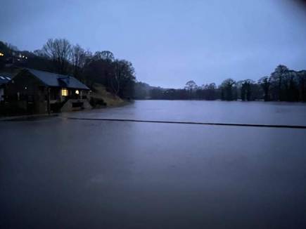
Flooding in Grindleford is happening with increasing frequency and significantly affects a number of houses along the riverbank, going from an every 20 years event to every one or two years.
In 2022, the Parish Council joined forces with an existing village group to form a Joint Flood Group and see if anything could be done to mitigate the effect of flooding.
There are a number of reasons why Grindleford floods.
- Flooding from the river – the project aimed to reduce or eliminate flooding for the houses along the bank from The Old Post Office to Glenavon, without worsening the situation for houses upstream of the bridge and below Glenavon.
- Flooding because of blockage at the bridge – the project addressed the best ways to monitor and manage flotsam hitting the bridge from upstream. We are particularly vulnerable because of our three-arch bridge.
- Surface run off – the project looked at working with other agencies on natural flood management measures upstream and on the hills.
- Reservoir capacity – the project liaised with EA, Severn Trent and other villages on the river, to attempt a review of legislation so that water is properly managed in the reservoirs
- Blocked drains – work is ongoing elsewhere to negotiate with Derbyshire County Council to keep the drains clear in a timely manner.
- FLOODING FROM THE RIVER
Dealing first with flooding from the river; water flows from the reservoir at Ladybower down through several villages. A combination of being in a steep sided valley, and water management at the reservoirs (see 4 above) means that Grindleford is liable to flooding. Unlike Hathersage upstream, the flood zone is in the centre of a residential area and flooding has significant effects on around ten houses, with others suffering from flooded gardens and outhouses.
Flooding in Grindleford is made particularly difficult as the river water comes into the village from three separate directions. Floodwater leaves the river at the top of the playing fields, floods the fields and exits via the cark park gate, crossing the road by the traffic lights before returning into the river via Jubilee Gardens and the track. When in spate, this joins water coming into Jubilee Gardens from the river, and the flood runs down the track and into gardens and basements. There it is joined by water coming over the bank at three low points, and also by water from the road which runs into the Old Post Office garden and down through the other gardens. Deciding the best way practically to stem all three flows is not at all easy, and there have been issues with different people having different views about the best solution.
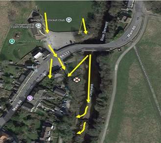
The flow of water as it is now
A major project was undertaken by the working group to determine whether a physical barrier along the side of the riverbank could be raised, to prevent overspill and ideally send the water over the other bank onto the flood plain (the Butterfly Field). The project ran for several years. Various parties involved were the Environment Agency, Derbyshire Wildlife Trust, the County Council, the Grindleford Flood Group and River Group, flood wardens, the Parish Council, the owners of the Butterfly Field and residents.
Issues arising were:
- Unknown ownership of the riverbank, which prevented us from getting a permit for riverside works from the Environment Agency. Matters of insurance and liability meant that we could not proceed without EA permission; without it, the flood group could be liable for any damage caused by the works which affects other houses downstream
- The risk of any intervention in one place worsening flooding in another.
- The need for flood barriers to complete the project and the cost and lack of funding.
Ownership of the bank. The last known owner was Mr John Stephenson Lister, who moved to Baslow and died in 1954. Research shows that he had four children and some grandchildren. It is likely that the four children have now also died; one was known to be living in the late 1990s, two had at that time deceased. Considerable effort was put into finding any remaining relatives without success. As a result, we were unable to apply to the EA for a formal permit to raise the bank.
A solution was found when we were told by the EA that we could apply for a certificate of exemption to restore the riverbank to previous levels. As there has been a great deal of work done on the riverbank by residents over the years, and it is in any event an undulating feature, the exact original level was not easy to determine, and so it was decided to use the highest existing point as a level. This point is next to Jubilee Gardens, ‘the mound’. Restoring the bank to this level is sufficient to allow the water to spill over onto the opposite bank, and prevent flooding on the houses side from water coming over the western bank.
Risk if intervention creates flooding elsewhere. This had for some time been one of the blocks to further intervention, particularly regarding the houses just upstream of the bridge. We were advised that the only way to get a definitive answer to this was to commission a professional flood risk assessment, to tell us what the impact of intervention would be. We were given the name of Environmental Land Management (ELMS), contact Gareth Trewick. We made efforts to find other companies to get competitive quotes. The only other company which we could find was JBA. Their quote was over £5000. They are a very reputable company but work with much bigger projects and their surveys and reports are over-engineered for a project such as ours. We asked the EA if they would approve ELMS, they were not able to do this but did give us written assurance that they would accept ELMS’ findings.
Liability. Our insurance policy already had a third party liability clause. The project involved the deployment of some inflatable flood barriers, see below, which we also wanted to check against our insurance. Once the flood risk assessment was finalised and accepted by the parish council, it was possible to approach our insurers, Zurich. The information at annex was presented to them and their reply is also there. Essentially as long as we followed the stipulations they made, they were able to insure us against third party in re the use of the barriers, for no cost, but not covering damage to them, or replacement. This was thought to be acceptable.
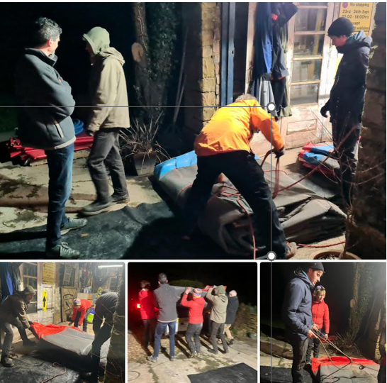
Flood barriers. A resident was able to secure us twenty free flood barriers, which was a stroke of very good fortune. Details of their deployment, dimensions, weight, issues with storage, insurance and where they are now are all at annex 3. For the purposes of the flood project, we now had six barriers to keep the water back at strategic points.
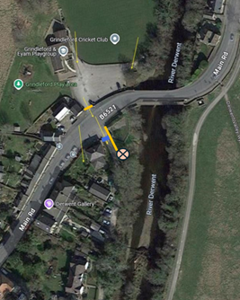
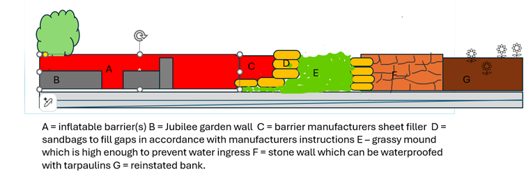
THE MITIGATION PLAN
Summary:
- To raise the bank from the dry stone wall opposite the Old Post Office all the way down the track
- To use flood barriers to stop ingress of water through Jubilee Gardens and up to the dry stone wall opposite the Old Post Office, protecting the top end by Jubilee Gardens
- To use flood barriers to block the entrance to the Pavilion carpark, and stop water flowing over the road.
- To protect the garden wall around Tommy’s Cottage with further flood barriers.

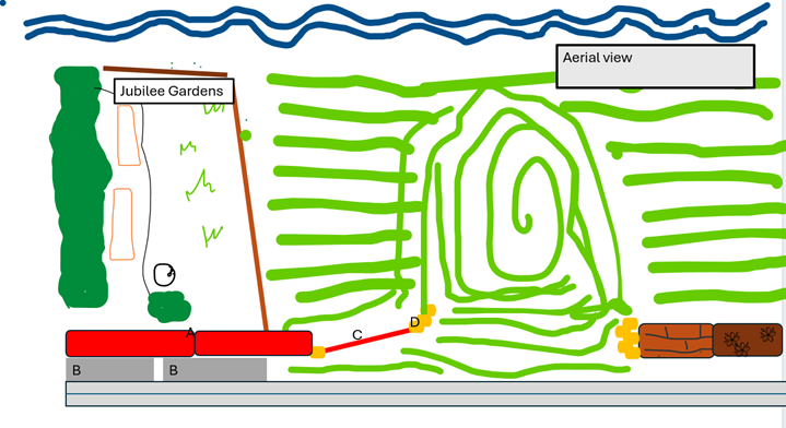
Rough pictorial representation of the plan

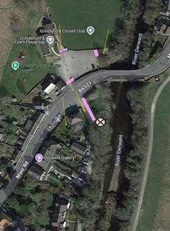
Ariel view
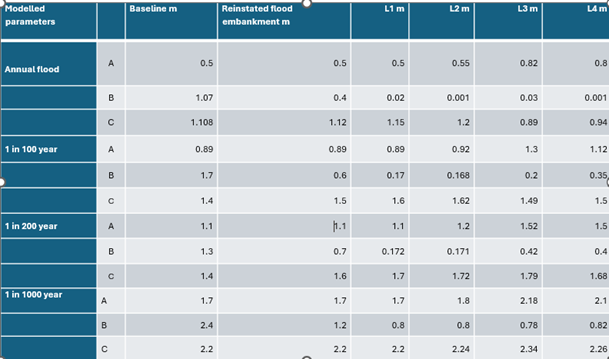
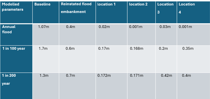
The flood risk assessment modelled the flow of the water just with the reinstated bank, ie without the intervention of flood barriers. Four further models were then run, assuming the bank reinstatement was in place, and with interventions of flood barriers at locations L1 – L4, as shown

Location 1 (orange) L1 and 2 (blue) L2 Location 3 (purple) L3 Location 4 (green)
Full details can be found in the attached flood risk assessment. In summary, ELMS identified the points where water came into the modelled area, where it flowed out and what existing barriers there were. They made some baseline measurements (assuming no reinstated bank and no flood barriers), then they picked three areas to model the rise in water, assuming a reinstated bank; the pavilion field (area A), by Jubilee Gardens (area B), and on the butterfly field by the water treatment works (area C).
The results of the modelling look like this:

An area of great concern was area A, the pavilion field, because that affects the two houses there (eg Toll Bar Cottage). These results are for area A only
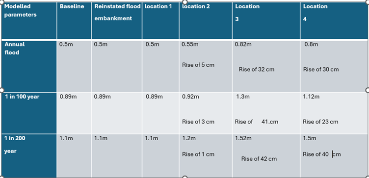
This shows that the reinstated bank makes no difference to the level of flood in location A, and that placing the barriers at location 1 (the orange option) also makes no difference. There is only a slight rise at location 2 (the blue option) but this option doesn’t keep the water from coming onto the track via the low points in the riverbank further downstream. Locations 3 (purple) and 4 (green) increase the flood level at area A by 30 cm or more so they are not tenable. Location 1 (orange) was therefore the only viable option.
Now let’s look at area B, just under the bridge downstream by Jubilee Gardens. With the barriers in place at location 1 (orange), the drop in water levels is significant.

What this shows us is that deployment of barriers at location 1 does not affect the height of the flood water at the Pavilion field, and does not therefore increase the severity of flooding to Toll Bar Cottage and adjacent houses, but they significantly reduce the level of flooding below the bridge, by Jubilee Gardens, therefore lessening the risk of flooding the houses along the riverbank between the Old Post Office and Glenavon. Reduced flood levels would also have an impact on the security of the sewage pipe.
NB Funding for the flood risk assessment was provided by compensation from Severn Trent for the disruption to the village during watermain repairs on the Froggatt Road. The parish council was able to negotiate this up from £1000 to £2500. The FRA was not therefore paid for from precept.
Outcome of the project
After a meeting with residents along the riverbank where each house was represented, there was agreement that residents would contribute to a local company carrying out the necessary work to reinstate the bank. The flood group felt strongly that such works could only be carried out with the consensus of all the residents. In the event, after the meeting two households felt that they did not want to go ahead as they felt the outcome was unknown and might worsen the flooding situation. The project was therefore halted at this point. The parish council and other key members therefore decided to withdraw from the flood group, and the project was indefinitely shelved. The flood group has now disbanded. This report, which will be lodged on the parish council website, is a summary of the project findings, should any future resident decide to revisit it.
Of the twenty flood barriers, fourteen were given to DDDC and DCC in return for funding to provide storage for the remaining six. Subsequently at time of writing, the six barriers may be given on loan to Castleton.
Further work. The project is not complete. There are one or two issues outstanding.
- Storage: unless the barriers go on loan to Castleton, a shed is required to put them in. At time of writing, Grindleford PFA were broadly happy to put the shed on the playing field.
- The flood risk assessment needs to be augmented to include the results if the bridge is blocked, which in time of real flood it usually is. ELMS can do this, but the project was shelved before that assessment was commissioned.
- Paul Birch at Tommy’s Cottage is unhappy about his wall (in the pavilion) being part of the flood defences. We retained enough flood barriers to go in front of his wall, but we need to reach formal agreement with him that the extra barriers will be satisfactory to him.
These are issues which must be addressed should any future person or group pick up the project.
- BLOCKAGE UPSTREAM OF THE BRIDGE
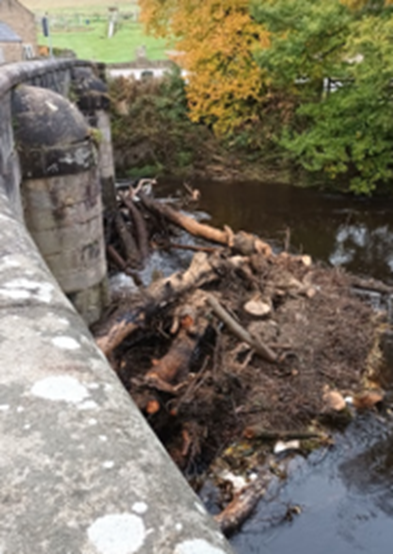
The flood risk assessment is predicated on the bridge being clear. The parish council asked ELMS to quote for remodelling assuming a one, two and three arch blockage, but the project was shelved before this was received.
Fishing clubs upstream strip tree trunks then moor them just off the bank, to create still pools for fish to breed in. Continued dialogue with fishing clubs upstream all the way up the reservoirs is needed to remind them to check their moorings in the winter months – or don’t do it all.
Landowners. Flood wardens patrol the river as far upstream as they can, and landowners can be asked to take down any branches or trees which look like they are going to fall in the river. If they refuse, the EA should be contacted. We do not have a list of landowners up the river and could usefully compile one.
Upstream catcher? Some sort of grill further up the river, perhaps by the weir, would be useful in terms of catching trees and branches before they get as far as the bridge. There are no plans or proposals for this – it would probably be more expensive than we can manage.
- THE IMPACT OF SURFACE AND RUN OFF WATER
The FRA looked at surface water and found Grindleford to be low risk. The flood group’s view is that surface water collecting is due to poor drain clearance. Many of the gulleys are blocked. Drain clearance by the council has for some time been outsourced and involves plunging the vertical shaft from the drain cover, but doing nothing to the horizontal gulleys which take the water away. Parish Council has been in discussions with the County Council, without success. We have also asked that Grindleford, because it floods so badly, should be scheduled after leave drop and not before it.
The Grindleford Flood Group is working long term with Derbyshire Wildlife Trust and FORD (Friends of the River Derwent) to install Natural Flood Management measures – leaky dams, natural barriers on hillsides and spill pools. Leaky dams and spill pools need to go in tributaries upstream, and landowner cooperation is required. Beavers have been released into the wild, which is a very positive step; but there are none here yet, and no plans to introduce any, although some might move up from places like Ashbourne.
- MANAGING THE WATER IN THE RESERVOIRS
Old legislation from 1975 means EA are legally bound to keep the reservoirs as full as possible from January to July to guard against drought. During a flood alert on New Year’s Eve the reservoir was 95.5% full despite weather warnings. There is a move to change the legislation so that it can be more flexible and able to respond to different weather patterns.
In November 2023 the Parish Council attended a session run by Sarah Dines MP which allowed councils to voice their concerns at a joint session. There we made contact with Prof Jeremy Higham, Dean of Education, Social Sciences and Law at Leeds who lives in Darley Dale and who is lobbying hard for a change in the legislation. In summary he has pressed the Environment Agency that “it is not appropriate to rely on an agreement based on the 1996 (or earlier) understanding of climate change and rainfall patterns and state “When the reservoirs are full, they will begin to ‘spill’ via overflow spillways.” This will also increase downstream river levels. Ladybower Reservoir was full by February, however this is outside of the Flood Drawdown Curve period so no further drawdowns can technically be requested. Clearly, this situation can be prevented, and surely we do not need to wait for a full review which won’t start for some time. Even to keep the reservoir at the agreed levels indicated in the current agreement’s Rules would be a start.”
5 FLOOD WARDENS
Grindleford has two new flood wardens, Chris Owen and Sam Marsh. The Clerk Sarah Battarbee is also a flood warden. All three recently attended Derbyshire Council Council flood warden training. With this completed, they are now covered by the parish council insurance.
Sarah Battarbee
Grindleford Parish Clerk
September 2025
Annex 1
The flood barriers
FORD, Friends of the River Derwent, are a village group comprising the hale and hearty. They always turn out (as individuals) in case of flood. If it should so happen that the project is resurrected, they have as of even date offered to help with putting the barriers up.
A rota would be required to make sure enough people would be in the village at any one time, eg New Year
The Clerk should be approached in the first instance about the rota.
Third party liability insurance is in place to insure the barriers, eg if someone is knocked into the river as a result of their deployment.
The barriers, which were a free gift the village, retail at around £3000 each. They are industrial barriers and to some extent over-spec for our needs, but we were unable to afford smaller barriers which would have cost a total of £4000. The barriers are not insured against damage or theft.
Deployment. EA confirmed that as the barriers would only be deployed and used in a flood emergency, their use would not require any sort of permit from the Environment Agency, although they asked to see a deployment plan if possible. The deployment would be as follows
- One by Jubilee Gardens along the inside of the wall onto the track
- Two across the pavilion car park gate
- Two or three around Paul Birch’s wall.
Dimensions are 140 cm x 120 cm x 25 cm. Weight unknown but heavy. They are difficult to move with fewer than four people, or a forklift.
Getting them from the storage to the riverbank will need a trailer or a forklift. Once inflated (which takes about 2 minutes) they are easy to move around. That ease of movement is potentially dangerous beside a flooded river. The barriers zip together to form a watertight join.
Training must be given to anyone deploying the barriers to ensure safe use {eg, how to lift them) and they must NEVER be deployed once the water has arrived. NEVER.
Derbyshire Dales District Council issue flood alerts and are usually at their desks when there is danger of flooding. As of the date of this report, ring Jim Fearn at DDDC 01629 761195 or Jim on 07775 931051, or email Jim.Fearn@derbyshiredales.gov.uk.
Met Office and EA flood alerts, which the Clerk and others in the village are signed up to, https://check-for-flooding.service.gov.uk/alerts-and-warnings, give information about when flooding is likely and when it is inevitable, and how much time we have before the water arrives. DDDC will attempt to tell us when it is time to inflate the barriers, contact Dave Turvey 07823 331511. The gauge at Mytham Bridge (Bamford) is our gauge. There is another downstream at Chatsworth.

Storage. The barriers need to be stored close to the river but are too big for people’s gardens
GPFA have given verbal permission to put a shed up where the old shed used to be on the Bridge Field. EA are content as long as they can get access to the bridge.
Where are they now? The six barriers which belong to the Parish Council are in storage at the ABC in Bakewell, contact Dave Turvey.
Annex 2
ELMS disclaimer
Report clause
This report has been created to inform on the basis of potential flood risk increase in proposed mitigating factors. The modelling undertaken is not exhaustive of all possible effects on flooding and only models potential flow dynamics and intervention outlined within defined parameters. ELMS therefore takes no responsibility for flooding that may occur outside of the defined parameter which are out of ELMS control as part of this consultation. These parameters could include change of land use locally or further afield as well as continued changes in climate or river characteristics.
We asked EMS: We are anxious as you know about liability if we put barriers somewhere in the village and a house which currently doesn’t flood gets damaged. We are reading your disclaimer to say that provided the situations we have specified exist when there is a flood, your report will give us protection against liability, but should we put the barriers somewhere else, climate change significantly alters the severity of floods, there are changes to the terrain (excluding the reinstated flood bank) or anything else, eg ST start letting water out of the reservoir differently, then the report does not cover that. Have I got that right?
ELMS have confirmed this in an email xxxxxxx.
Annex 3
Insurance – flood wardens, barriers
We are insured with Zurich International Grindleford Parish Council: YLL-122008-6953.
We have insured the flood barriers under our existing policy (under third party liability) for no extra cost.
This is confirmation from Zurich
| GBZ_ZT_Renewals Team <renewals.team@uk.zurich.com> | Apr 17, 2025, 3:04 PM | ||
| to me, ANDREW | |||
Good Afternoon Sarah,
Thank you for your email providing us with further information.
I can confirm that the flood barrier will be covered under your policy.
Please note so that the flood barriers are covered under the policy please ensure that the barriers are inspected at intervals (and this is documented) to ensure they remain in good condition and that you have trained enough volunteers, so that if an alert comes in there are always people on hand to deploy the barriers.
If you have any further queries, please let us know.
We have also insured the flood wardens, for no extra cost.
| GBZ_ZT_Renewals Team <renewals.team@uk.zurich.com> | Tue, Sep 2, 10:01 AM | ||
| to me | |||
Good Morning, Sarah
Thank you for coming back so quickly.
I will update our records accordingly and can confirm that your new volunteers will be covered under your Policy.
Best regards
Ethan Samuels
Digital Trading Trainee Underwriter
| Zurich Municipal |
Annex 4
EA exemption confirmation
Hi Simon, Tim and Dave
Email from Dave Kirkup to the EA, asking for confirmation that we were eligible for an exemption if we reinstated the riverbank to its former height.
“Firstly, thank you all and your colleague for coming out again to provide on-site advice and considerations with regard to our application for an Exemption Permit. We know and appreciate how busy you are and how valuable your time is – it really does help and we are very grateful.
In forwarding Tim’s previous email setting out our ‘next steps’ I thought it would help in clarifying if we have any other factors or insights to consider on the back of this latest visit. Do please pass on any thoughts or advice in addition to that contained below in Tim’s comprehensive email.
We are actively pursuing an FIA with ELMS and Gareth Trewick, someone who you have worked with and recognise as a competent practitioner. Further to our meeting of the Grindleford Parish Council on Thursday 8/8/24 after your visit, the committee required further clarification of our conversation.
- Could you confirm again but in writing* that ELMS are a suitable organisation to complete an FIA that would be recognised and accepted by the EA with regard to any Exemption Application.
- The GPC were also concerned that we should have a competing quote from a second organisation certified by the EA who could provide a suitable FIA. Could you recommend such an organisation please?
Thanks in advance for the above – I would like to allay any fears the PC have about releasing the funding for the above ASAP.”
Best regards,
Dave
On behalf of Grindleford PC and GFG
*written confirmation requested from Dave Kirkup.
Grindleford exemption, should we at some point wish to restore the riverbank to its original levels.
Your reference is EXFRA014290
Exemption registered
Maintaining a raised river or sea defence FRA8
at grid reference SK 24448 77687.
Before you start work
Check you can meet the exemption conditions
You should re-check you can meet the description and conditions of your exemption in the flood risk exemptions guidance:
https://www.gov.uk/government/publications/environmental-permitting-regulations-exempt-flood-risk-activities
Other things to check
You should check if there are protected species in the area. If there are, you must make sure your activity doesn’t harm them. You may also need planning permission and to get the landowner’s permission to enter the land.
Date of registration
09 October 2024 09:40
Exemptions don’t expire except for dredging FRA23 which expires 3 years after the registration date and dredging FRA24 which expires 1 year after the registration date.
Responsible for activity (the ‘operator’)
David Kirkup, GLENAVON, MAIN ROAD, GRINDLEFORD, HOPE VALLEY, S32 2JN
Who we will contact
David KIRKUP,
Tel: 07761764568
Responsibilities of the operator
The organisation or individual responsible must keep to the description and conditions for the exemption. We can prosecute them if they don’t do this.
Annex 5
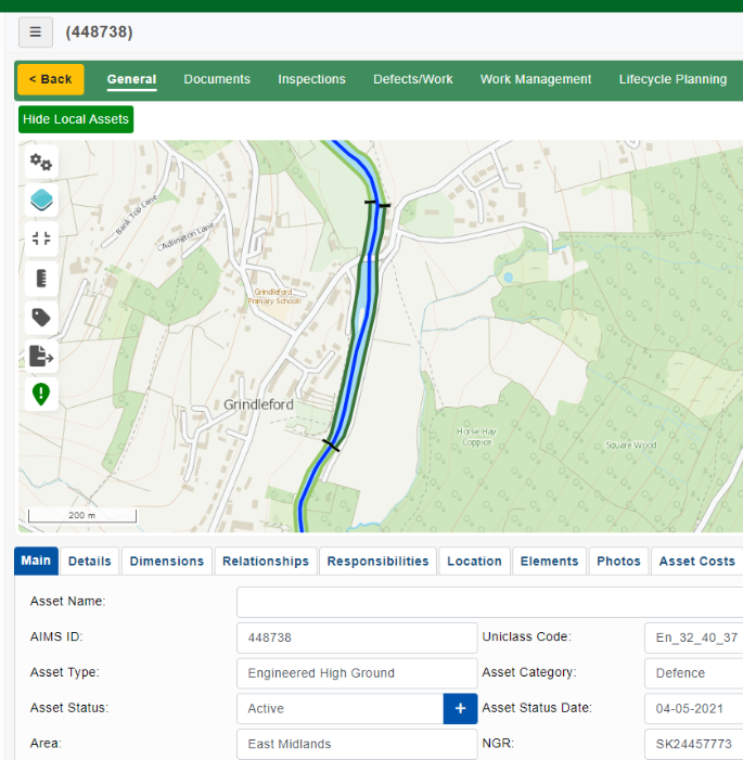
Possibility of the riverbank being declared Engineering High Ground
If the riverbank were Engineering High Ground we might not have needed a permit for that reason. At one point EA thought that the bank was EHG, but later reversed that opinion. This Annex is for information only should it ever be relevant in the future. This email is from the EA.
“I’ve had another reply from the estates team, according to their maps there are no flood defence assets shown in Grindleford, instead only Engineered High Ground ( EHG ) assets and this looks to be an error. EHG is where usually some form of building or riverbank revetment that is not natural but is not designed as a flood defence.
At Grindleford we show only EHG currently on both banks through the village ( see screen grab below ) but this should be Natural High Ground and looking at the photos the estates team agrees. EHG is a new asset type that has never been in the pre-OM system so there are lots of instances across the database where it shows one or the other that the team hasn’t had time to amend yet.

Annex 6
Thanks to:
Stakeholders
GRINDLEFORD FLOODING MITIGATION PROJECT
ON BEHALF OF GRINDLEFORD FLOOD GROUP December 2025
INTRODUCTION
This report details work undertaken by the Grindleford Flood Group to mitigate flooding in the village. The project was based on ‘self-help’ as the Environment Agency, whose responsibility flooding is, were unable to provide the priority funding for a community our size (although they were helpful with advice). The work built on the former flood group’s well-established flood plans.
BACKGROUND
Flooding in Grindleford is happening with increasing frequency and significantly affects a number of houses along the riverbank, going from an every 20 years event to every one or two years.
In 2022, the Parish Council joined forces with an existing village group to form a Joint Flood Group and see if anything could be done to mitigate the effect of flooding.
There are a number of reasons why Grindleford floods.
- Flooding from the river – the project aimed to reduce or eliminate flooding for the houses along the bank from The Old Post Office to Glenavon, without worsening the situation for houses upstream of the bridge and below Glenavon.
- Flooding because of blockage at the bridge – the project addressed the best ways to monitor and manage flotsam hitting the bridge from upstream. We are particularly vulnerable because of our three-arch bridge.
- Surface run off – the project looked at working with other agencies on natural flood management measures upstream and on the hills.
- Reservoir capacity – the project liaised with EA, Severn Trent and other villages on the river, to attempt a review of legislation so that water is properly managed in the reservoirs
- Blocked drains – work is ongoing elsewhere to negotiate with Derbyshire County Council to keep the drains clear in a timely manner.
- FLOODING FROM THE RIVER
Dealing first with flooding from the river; water flows from the reservoir at Ladybower down through several villages. A combination of being in a steep sided valley, and water management at the reservoirs (see 4 above) means that Grindleford is liable to flooding. Unlike Hathersage upstream, the flood zone is in the centre of a residential area and flooding has significant effects on around ten houses, with others suffering from flooded gardens and outhouses.
Flooding in Grindleford is made particularly difficult as the river water comes into the village from three separate directions. Floodwater leaves the river at the top of the playing fields, floods the fields and exits via the cark park gate, crossing the road by the traffic lights before returning into the river via Jubilee Gardens and the track. When in spate, this joins water coming into Jubilee Gardens from the river, and the flood runs down the track and into gardens and basements. There it is joined by water coming over the bank at three low points, and also by water from the road which runs into the Old Post Office garden and down through the other gardens. Deciding the best way practically to stem all three flows is not at all easy, and there have been issues with different people having different views about the best solution.

The flow of water as it is now
A major project was undertaken by the working group to determine whether a physical barrier along the side of the riverbank could be raised, to prevent overspill and ideally send the water over the other bank onto the flood plain (the Butterfly Field). The project ran for several years. Various parties involved were the Environment Agency, Derbyshire Wildlife Trust, the County Council, the Grindleford Flood Group and River Group, flood wardens, the Parish Council, the owners of the Butterfly Field and residents.
Issues arising were:
- Unknown ownership of the riverbank, which prevented us from getting a permit for riverside works from the Environment Agency. Matters of insurance and liability meant that we could not proceed without EA permission; without it, the flood group could be liable for any damage caused by the works which affects other houses downstream
- The risk of any intervention in one place worsening flooding in another.
- The need for flood barriers to complete the project and the cost and lack of funding.
Ownership of the bank. The last known owner was Mr John Stephenson Lister, who moved to Baslow and died in 1954. Research shows that he had four children and some grandchildren. It is likely that the four children have now also died; one was known to be living in the late 1990s, two had at that time deceased. Considerable effort was put into finding any remaining relatives without success. As a result, we were unable to apply to the EA for a formal permit to raise the bank.
A solution was found when we were told by the EA that we could apply for a certificate of exemption to restore the riverbank to previous levels. As there has been a great deal of work done on the riverbank by residents over the years, and it is in any event an undulating feature, the exact original level was not easy to determine, and so it was decided to use the highest existing point as a level. This point is next to Jubilee Gardens, ‘the mound’. Restoring the bank to this level is sufficient to allow the water to spill over onto the opposite bank, and prevent flooding on the houses side from water coming over the western bank.
Risk if intervention creates flooding elsewhere. This had for some time been one of the blocks to further intervention, particularly regarding the houses just upstream of the bridge. We were advised that the only way to get a definitive answer to this was to commission a professional flood risk assessment, to tell us what the impact of intervention would be. We were given the name of Environmental Land Management (ELMS), contact Gareth Trewick. We made efforts to find other companies to get competitive quotes. The only other company which we could find was JBA. Their quote was over £5000. They are a very reputable company but work with much bigger projects and their surveys and reports are over-engineered for a project such as ours. We asked the EA if they would approve ELMS, they were not able to do this but did give us written assurance that they would accept ELMS’ findings.
Liability. Our insurance policy already had a third party liability clause. The project involved the deployment of some inflatable flood barriers, see below, which we also wanted to check against our insurance. Once the flood risk assessment was finalised and accepted by the parish council, it was possible to approach our insurers, Zurich. The information at annex was presented to them and their reply is also there. Essentially as long as we followed the stipulations they made, they were able to insure us against third party in re the use of the barriers, for no cost, but not covering damage to them, or replacement. This was thought to be acceptable.
Flood barriers. A resident was able to secure us twenty free flood barriers, which was a stroke of very good fortune. Details of their deployment, dimensions, weight, issues with storage, insurance and where they are now are all at annex 3. For the purposes of the flood project, we now had six barriers to keep the water back at strategic points.
THE MITIGATION PLAN
Summary:
- To raise the bank from the dry stone wall opposite the Old Post Office all the way down the track
- To use flood barriers to stop ingress of water through Jubilee Gardens and up to the dry stone wall opposite the Old Post Office, protecting the top end by Jubilee Gardens
- To use flood barriers to block the entrance to the Pavilion carpark, and stop water flowing over the road.
- To protect the garden wall around Tommy’s Cottage with further flood barriers.
Rough pictorial representation of the plan
Ariel view
The flood risk assessment modelled the flow of the water just with the reinstated bank, ie without the intervention of flood barriers. Four further models were then run, assuming the bank reinstatement was in place, and with interventions of flood barriers at locations L1 – L4, as shown

Location 1 (orange) L1 and 2 (blue) L2 Location 3 (purple) L3 Location 4 (green)
Full details can be found in the attached flood risk assessment. In summary, ELMS identified the points where water came into the modelled area, where it flowed out and what existing barriers there were. They made some baseline measurements (assuming no reinstated bank and no flood barriers), then they picked three areas to model the rise in water, assuming a reinstated bank; the pavilion field (area A), by Jubilee Gardens (area B), and on the butterfly field by the water treatment works (area C).
The results of the modelling look like this:
An area of great concern was area A, the pavilion field, because that affects the two houses there (eg Toll Bar Cottage). These results are for area A only

This shows that the reinstated bank makes no difference to the level of flood in location A, and that placing the barriers at location 1 (the orange option) also makes no difference. There is only a slight rise at location 2 (the blue option) but this option doesn’t keep the water from coming onto the track via the low points in the riverbank further downstream. Locations 3 (purple) and 4 (green) increase the flood level at area A by 30 cm or more so they are not tenable. Location 1 (orange) was therefore the only viable option.
Now let’s look at area B, just under the bridge downstream by Jubilee Gardens. With the barriers in place at location 1 (orange), the drop in water levels is significant.
What this shows us is that deployment of barriers at location 1 does not affect the height of the flood water at the Pavilion field, and does not therefore increase the severity of flooding to Toll Bar Cottage and adjacent houses, but they significantly reduce the level of flooding below the bridge, by Jubilee Gardens, therefore lessening the risk of flooding the houses along the riverbank between the Old Post Office and Glenavon. Reduced flood levels would also have an impact on the security of the sewage pipe.
NB Funding for the flood risk assessment was provided by compensation from Severn Trent for the disruption to the village during watermain repairs on the Froggatt Road. The parish council was able to negotiate this up from £1000 to £2500. The FRA was not therefore paid for from precept.
Outcome of the project
After a meeting with residents along the riverbank where each house was represented, there was agreement that residents would contribute to a local company carrying out the necessary work to reinstate the bank. The flood group felt strongly that such works could only be carried out with the consensus of all the residents. In the event, after the meeting two households felt that they did not want to go ahead as they felt the outcome was unknown and might worsen the flooding situation. The project was therefore halted at this point. The parish council and other key members therefore decided to withdraw from the flood group, and the project was indefinitely shelved. The flood group has now disbanded. This report, which will be lodged on the parish council website, is a summary of the project findings, should any future resident decide to revisit it.
Of the twenty flood barriers, fourteen were given to DDDC and DCC in return for funding to provide storage for the remaining six. Subsequently at time of writing, the six barriers may be given on loan to Castleton.
Further work. The project is not complete. There are one or two issues outstanding.
- Storage: unless the barriers go on loan to Castleton, a shed is required to put them in. At time of writing, Grindleford PFA were broadly happy to put the shed on the playing field.
- The flood risk assessment needs to be augmented to include the results if the bridge is blocked, which in time of real flood it usually is. ELMS can do this, but the project was shelved before that assessment was commissioned.
- Paul Birch at Tommy’s Cottage is unhappy about his wall (in the pavilion) being part of the flood defences. We retained enough flood barriers to go in front of his wall, but we need to reach formal agreement with him that the extra barriers will be satisfactory to him.
These are issues which must be addressed should any future person or group pick up the project.
- BLOCKAGE UPSTREAM OF THE BRIDGE

The flood risk assessment is predicated on the bridge being clear. The parish council asked ELMS to quote for remodelling assuming a one, two and three arch blockage, but the project was shelved before this was received.
Fishing clubs upstream strip tree trunks then moor them just off the bank, to create still pools for fish to breed in. Continued dialogue with fishing clubs upstream all the way up the reservoirs is needed to remind them to check their moorings in the winter months – or don’t do it all.
Landowners. Flood wardens patrol the river as far upstream as they can, and landowners can be asked to take down any branches or trees which look like they are going to fall in the river. If they refuse, the EA should be contacted. We do not have a list of landowners up the river and could usefully compile one.
Upstream catcher? Some sort of grill further up the river, perhaps by the weir, would be useful in terms of catching trees and branches before they get as far as the bridge. There are no plans or proposals for this – it would probably be more expensive than we can manage.
- THE IMPACT OF SURFACE AND RUN OFF WATER
The FRA looked at surface water and found Grindleford to be low risk. The flood group’s view is that surface water collecting is due to poor drain clearance. Many of the gulleys are blocked. Drain clearance by the council has for some time been outsourced and involves plunging the vertical shaft from the drain cover, but doing nothing to the horizontal gulleys which take the water away. Parish Council has been in discussions with the County Council, without success. We have also asked that Grindleford, because it floods so badly, should be scheduled after leave drop and not before it.
The Grindleford Flood Group is working long term with Derbyshire Wildlife Trust and FORD (Friends of the River Derwent) to install Natural Flood Management measures – leaky dams, natural barriers on hillsides and spill pools. Leaky dams and spill pools need to go in tributaries upstream, and landowner cooperation is required. Beavers have been released into the wild, which is a very positive step; but there are none here yet, and no plans to introduce any, although some might move up from places like Ashbourne.
- MANAGING THE WATER IN THE RESERVOIRS
Old legislation from 1975 means EA are legally bound to keep the reservoirs as full as possible from January to July to guard against drought. During a flood alert on New Year’s Eve the reservoir was 95.5% full despite weather warnings. There is a move to change the legislation so that it can be more flexible and able to respond to different weather patterns.
In November 2023 the Parish Council attended a session run by Sarah Dines MP which allowed councils to voice their concerns at a joint session. There we made contact with Prof Jeremy Higham, Dean of Education, Social Sciences and Law at Leeds who lives in Darley Dale and who is lobbying hard for a change in the legislation. In summary he has pressed the Environment Agency that “it is not appropriate to rely on an agreement based on the 1996 (or earlier) understanding of climate change and rainfall patterns and state “When the reservoirs are full, they will begin to ‘spill’ via overflow spillways.” This will also increase downstream river levels. Ladybower Reservoir was full by February, however this is outside of the Flood Drawdown Curve period so no further drawdowns can technically be requested. Clearly, this situation can be prevented, and surely we do not need to wait for a full review which won’t start for some time. Even to keep the reservoir at the agreed levels indicated in the current agreement’s Rules would be a start.”
5 FLOOD WARDENS
Grindleford has two new flood wardens, Chris Owen and Sam Marsh. The Clerk Sarah Battarbee is also a flood warden. All three recently attended Derbyshire Council Council flood warden training. With this completed, they are now covered by the parish council insurance.
Sarah Battarbee
Grindleford Parish Clerk
September 2025
Annex 1
The flood barriers
FORD, Friends of the River Derwent, are a village group comprising the hale and hearty. They always turn out (as individuals) in case of flood. If it should so happen that the project is resurrected, they have as of even date offered to help with putting the barriers up.
A rota would be required to make sure enough people would be in the village at any one time, eg New Year
The Clerk should be approached in the first instance about the rota.
Third party liability insurance is in place to insure the barriers, eg if someone is knocked into the river as a result of their deployment.
The barriers, which were a free gift the village, retail at around £3000 each. They are industrial barriers and to some extent over-spec for our needs, but we were unable to afford smaller barriers which would have cost a total of £4000. The barriers are not insured against damage or theft.
Deployment. EA confirmed that as the barriers would only be deployed and used in a flood emergency, their use would not require any sort of permit from the Environment Agency, although they asked to see a deployment plan if possible. The deployment would be as follows
- One by Jubilee Gardens along the inside of the wall onto the track
- Two across the pavilion car park gate
- Two or three around Paul Birch’s wall.
Dimensions are 140 cm x 120 cm x 25 cm. Weight unknown but heavy. They are difficult to move with fewer than four people, or a forklift.
Getting them from the storage to the riverbank will need a trailer or a forklift. Once inflated (which takes about 2 minutes) they are easy to move around. That ease of movement is potentially dangerous beside a flooded river. The barriers zip together to form a watertight join.
Training must be given to anyone deploying the barriers to ensure safe use {eg, how to lift them) and they must NEVER be deployed once the water has arrived. NEVER.
Derbyshire Dales District Council issue flood alerts and are usually at their desks when there is danger of flooding. As of the date of this report, ring Jim Fearn at DDDC 01629 761195 or Jim on 07775 931051, or email Jim.Fearn@derbyshiredales.gov.uk.
Met Office and EA flood alerts, which the Clerk and others in the village are signed up to, https://check-for-flooding.service.gov.uk/alerts-and-warnings, give information about when flooding is likely and when it is inevitable, and how much time we have before the water arrives. DDDC will attempt to tell us when it is time to inflate the barriers, contact Dave Turvey 07823 331511. The gauge at Mytham Bridge (Bamford) is our gauge. There is another downstream at Chatsworth.
Storage. The barriers need to be stored close to the river but are too big for people’s gardens
GPFA have given verbal permission to put a shed up where the old shed used to be on the Bridge Field. EA are content as long as they can get access to the bridge.
Where are they now? The six barriers which belong to the Parish Council are in storage at the ABC in Bakewell, contact Dave Turvey.
Annex 2
ELMS disclaimer
Report clause
This report has been created to inform on the basis of potential flood risk increase in proposed mitigating factors. The modelling undertaken is not exhaustive of all possible effects on flooding and only models potential flow dynamics and intervention outlined within defined parameters. ELMS therefore takes no responsibility for flooding that may occur outside of the defined parameter which are out of ELMS control as part of this consultation. These parameters could include change of land use locally or further afield as well as continued changes in climate or river characteristics.
We asked EMS: We are anxious as you know about liability if we put barriers somewhere in the village and a house which currently doesn’t flood gets damaged. We are reading your disclaimer to say that provided the situations we have specified exist when there is a flood, your report will give us protection against liability, but should we put the barriers somewhere else, climate change significantly alters the severity of floods, there are changes to the terrain (excluding the reinstated flood bank) or anything else, eg ST start letting water out of the reservoir differently, then the report does not cover that. Have I got that right?
ELMS have confirmed this in an email xxxxxxx.
Annex 3
Insurance – flood wardens, barriers
We are insured with Zurich International Grindleford Parish Council: YLL-122008-6953.
We have insured the flood barriers under our existing policy (under third party liability) for no extra cost.
This is confirmation from Zurich
| GBZ_ZT_Renewals Team <renewals.team@uk.zurich.com> | Apr 17, 2025, 3:04 PM | ||
| to me, ANDREW | |||
Good Afternoon Sarah,
Thank you for your email providing us with further information.
I can confirm that the flood barrier will be covered under your policy.
Please note so that the flood barriers are covered under the policy please ensure that the barriers are inspected at intervals (and this is documented) to ensure they remain in good condition and that you have trained enough volunteers, so that if an alert comes in there are always people on hand to deploy the barriers.
If you have any further queries, please let us know.
We have also insured the flood wardens, for no extra cost.
| GBZ_ZT_Renewals Team <renewals.team@uk.zurich.com> | Tue, Sep 2, 10:01 AM | ||
| to me | |||
Good Morning, Sarah
Thank you for coming back so quickly.
I will update our records accordingly and can confirm that your new volunteers will be covered under your Policy.
Best regards
Ethan Samuels
Digital Trading Trainee Underwriter
| Zurich Municipal |
Annex 4
EA exemption confirmation
Hi Simon, Tim and Dave
Email from Dave Kirkup to the EA, asking for confirmation that we were eligible for an exemption if we reinstated the riverbank to its former height.
“Firstly, thank you all and your colleague for coming out again to provide on-site advice and considerations with regard to our application for an Exemption Permit. We know and appreciate how busy you are and how valuable your time is – it really does help and we are very grateful.
In forwarding Tim’s previous email setting out our ‘next steps’ I thought it would help in clarifying if we have any other factors or insights to consider on the back of this latest visit. Do please pass on any thoughts or advice in addition to that contained below in Tim’s comprehensive email.
We are actively pursuing an FIA with ELMS and Gareth Trewick, someone who you have worked with and recognise as a competent practitioner. Further to our meeting of the Grindleford Parish Council on Thursday 8/8/24 after your visit, the committee required further clarification of our conversation.
- Could you confirm again but in writing* that ELMS are a suitable organisation to complete an FIA that would be recognised and accepted by the EA with regard to any Exemption Application.
- The GPC were also concerned that we should have a competing quote from a second organisation certified by the EA who could provide a suitable FIA. Could you recommend such an organisation please?
Thanks in advance for the above – I would like to allay any fears the PC have about releasing the funding for the above ASAP.”
Best regards,
Dave
On behalf of Grindleford PC and GFG
*written confirmation requested from Dave Kirkup.
Grindleford exemption, should we at some point wish to restore the riverbank to its original levels.
Your reference is EXFRA014290
Exemption registered
Maintaining a raised river or sea defence FRA8
at grid reference SK 24448 77687.
Before you start work
Check you can meet the exemption conditions
You should re-check you can meet the description and conditions of your exemption in the flood risk exemptions guidance:
https://www.gov.uk/government/publications/environmental-permitting-regulations-exempt-flood-risk-activities
Other things to check
You should check if there are protected species in the area. If there are, you must make sure your activity doesn’t harm them. You may also need planning permission and to get the landowner’s permission to enter the land.
Date of registration
09 October 2024 09:40
Exemptions don’t expire except for dredging FRA23 which expires 3 years after the registration date and dredging FRA24 which expires 1 year after the registration date.
Responsible for activity (the ‘operator’)
David Kirkup, GLENAVON, MAIN ROAD, GRINDLEFORD, HOPE VALLEY, S32 2JN
Who we will contact
David KIRKUP,
Tel: 07761764568
Responsibilities of the operator
The organisation or individual responsible must keep to the description and conditions for the exemption. We can prosecute them if they don’t do this.
Annex 5
Possibility of the riverbank being declared Engineering High Ground
If the riverbank were Engineering High Ground we might not have needed a permit for that reason. At one point EA thought that the bank was EHG, but later reversed that opinion. This Annex is for information only should it ever be relevant in the future. This email is from the EA.
“I’ve had another reply from the estates team, according to their maps there are no flood defence assets shown in Grindleford, instead only Engineered High Ground ( EHG ) assets and this looks to be an error. EHG is where usually some form of building or riverbank revetment that is not natural but is not designed as a flood defence.
At Grindleford we show only EHG currently on both banks through the village ( see screen grab below ) but this should be Natural High Ground and looking at the photos the estates team agrees. EHG is a new asset type that has never been in the pre-OM system so there are lots of instances across the database where it shows one or the other that the team hasn’t had time to amend yet.
Annex 6
Thanks to:
Stakeholders
- Residents, in particular Dave Kirkup and Alan Fairbrother
- Grindleford flood group
- River Wardens present and past, in particular John Wood, Nick Bater, John Baily and Bob Wilson
- FORD River Group
- Parish Council
- Environment Agency
- Severn Trent
- Derbyshire County Council
- Derbyshire Dales District Council
- Derbyshire Wildlife Trust, in particular George Jones
- Prof Jeremy Higham Darley Bridge – (let down from the reservoir)